Koʻolau Loa Plan
GO TO: About | Central Oʻahu | East Honolulu | ʻEwa | Koʻolau Loa | Koʻolau Poko | North Shore | Primary Urban Center | Waiʻanae
Koʻolau Loa Watershed Management Plan
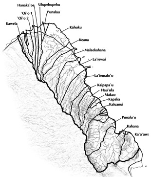
The Koʻolau Loa District consists of a 58 square-mile area on the windward side of the Koʻolau Mountains from Kaaawa to Kawela. It is one of the eight district Watershed Management Plans that together will constitute the Oʻahu Watershed Management Plan. The Honolulu Board of Water Supply (BWS) has completed the development of the district-wide Koolau Loa Watershed Management Plan (KLWMP), which will be used to meet the requirements of preparing a county water use and development plan under the State of Hawaii Water Code and City and County of Honolulu ordinance.
Final Plan
The Koʻolau Loa Watershed Management Plan was finalized in August 2009. Throughout the project, public "working group" meetings and other forms of consultations were held with community leaders, community groups and organizations, landowners, and public agencies.
Goal
The overall goal of the KLWMP is to formulate an environmentally holistic, community-based, and economically viable watershed management plan that will provide a balance between:
- the preservation and management of Oʻahu's watersheds, and
- sustainable ground water and surface water use and development to serve present users and future generations.
About this Plan
Send an email to contactus@hbws.org
Plan Area
Koʻolau Loa District, from Waialee to Kaoio Point (Kaaawa to Kahuku)
District Size
37,201 acres; approximately 15,000 people
Communities
Kaaawa, Kahana, Punaluu, Hauula, Laie, Kahuku
Water Use
For More Information
|
Group 70 International, Inc. |
|
| Board of Water Supply Contact: Barry Usagawa Phone: (808) 748-5900 Email: busagawa@hbws.org |