NUʻUANU DAMS
Nuʻuanu Reservoir No. 4 Dam
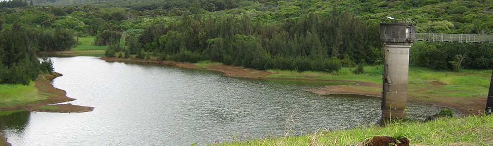
Nuʻuanu Reservoir No. 4 Dam is located on the Diamond Head-side of Pali Highway above Nuʻuanu Pali Dr.
BWS operation of Nuʻuanu Reservoir No. 4 Dam:
BWS keeps the reservoir at least half full, or at a water depth of approximately 30 feet to maintain adequate flood control storage capacity, by keeping the middle gate of the intake tower open. Water from the reservoir drains via a 24-inch diameter pipeline through the dam and into Lulumahu Stream and ultimately Nuʻuanu Stream.
What level does the water need to reach to require mandatory evacuation?
When the water level reaches a foot below the top of the dam, a mandatory evacuation notice will be issued. (The City Department of Emergency Management (DEM) and the State Department of Land and Natural Resources (DLNR) are currently reviewing evacuation triggers and will update their plans as necessary.) BWS is working with the DEM to coordinate the evacuation plan, which includes public evacuation notification and designation of evacuation centers, only if needed.
If I need to be evacuated, how will BWS notify me?
BWS will work with the City Department of Emergency Management (DEM) and other city agencies to provide notice to the affected residents. Should evacuation become mandatory, personnel from the Honolulu Police Department, Honolulu Fire Department, and DEM will notify the community.
In the event of a mandatory evacuation, where can I find an evacuation center?
Locations of evacuation centers would be provided to community leaders and the media to share with the public. Stay tuned to local news media and social media channels for up-to-the-minute information. Residents would need to bring everything they might need for at least 24 hours – food, water, bedding, toiletries, etc. The evacuation shelters would only provide a place to stay.
Do you have a list of streets in the evacuation zone so I can see if I live in that area?
BWS worked with DEM to determine the extent of the evacuation zone. See list of streets currently identified in the 96813 zip code and currently identified in the 96817 zip code for the Nuuanu Reservoir No. 4 dam evacuation zone, and reference the current evacuation zone map and description below. Subject to change.
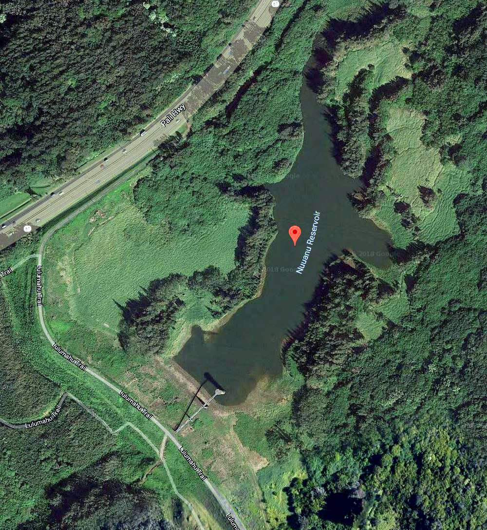
Aerial View of Nuʻuanu No. 4 Dam
RESOURCES & RECENT UPDATES
Are You in a Nuʻuanu Reservoir No. 4 Evacuation Zone?
- Streets in Nuʻuanu No. 4 Evacuation Zone (96813)
- Streets in Nuʻuanu No. 4 Evacuation Zone (96817)
- All Streets in the Nuʻuanu No. 1 and No. 4 Evacuation Zones
BWS Updates for Nuʻuanu Reservoir No. 4
- Letter to Residents in 96813 and 96817 (February 2019)
- Nuʻuanu Reservoir No. 4 Fact Sheet (February 2019)
- Controlled Water Level Reduction Scheduled (February 2019)
BWS and DEM Presentations to Liliha Neighborhood Board
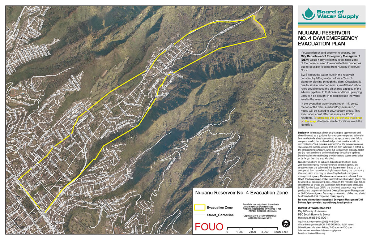
Nuʻuanu Reservoir No. 4 Dam Emergency Evacuation Plan
- If evacuation should become necessary, the City Department of Emergency Management (DEM) would notify residents in the flood zone of the potential need to evacuate their properties due to possible flooding from Nuʻuanu Reservoir No. 4.
- BWS keeps the water level in the reservoir constant by letting water out via a 24-inch diameter pipeline through the dam. Occasionally, due to severe weather events, rainfall and inflow rates could exceed the discharge capacity of the 24-inch pipeline. In that case, additional pumping units can be brought in to help reduce the water level in the reservoir.
- In the event that water levels reach 1 ft. below the top of the dam, a mandatory evacuation notice will be issued to downstream areas. This evacuation could affect as many as 12,000 residents. (Please see the yellow-outlined area on the map.) Potential shelter locations would be identified.
Disclaimer: Information shown on the map is approximate and should be used as a guideline for emergency response. While the best available data has been utilized as inputs into a dam failure computer model, the final modeled product results should be interpreted as “best available estimates” of the evacuation areas. The computer models assume that the dam fails from a defect in the embankment structure, while full at maximum capacity, under dry (no rain) conditions and no discharge through the spillway. Dam breaches during flooding or other hazard events could differ or be larger than the area identified. Should evacuations be initiated, listen to instructions from your local emergency management/civil defense agency, and directives from the police and fire departments. Based on the anticipated dam hazard or multiple hazards facing the community, this evacuation area may be altered by the local emergency management agency. The dam evacuation area is different from FEMA flood zone maps or the Tsunami Evacuation Maps (those can be viewed at: gis.hawaiinfip.org). Although the modeled dam failure area utilized to create the evacuation zone maps were conducted by PDC for the State DLNR, the displayed evacuation map is the product and property of the local County Emergency Management or Civil Defense Agency. Any usage or alteration of this map should be cleared with that respective county agency.
Evacuation Zone Information: http://dlnreng.hawaii.gov/dam.
FAST FACTS: NUUANU DAM NO. 4
- State Dam ID: OA-0001
- Year completed: 1910 (Original),
1933 (Reconstruction) - Purpose: flood control; water supply
- Dam type: Earthen
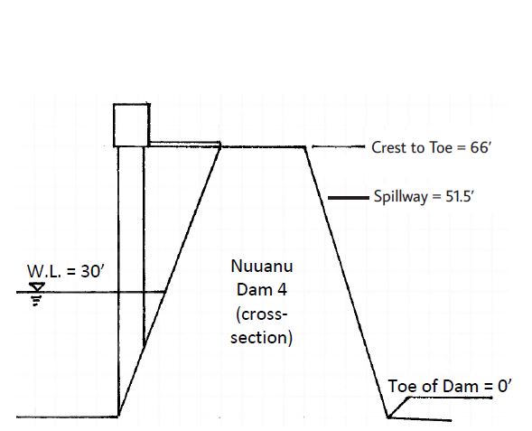
- Dam height: 66 feet
- Minimum crest width: 25 feet
- Dam length: 2,120 feet
- Storage: 79 million gallons
- Surface area: 25 acres
NOTE: Information is current as of the time it was posted online and is subject to change and update as new information becomes available.
Updated: 10/03/2023